


2023 MEGA Roundup!
Oh, just all the imagery from 2023!

Happy New Year! This is a massive amount of imagery for Substack I hope it doesn’t cause any performance issues for you!
All of my satellite imagery is crowd funded, If you like this sorta thing please consider subscribing and sharing!
Updated heat map showing UK Maritime Trade Organization "Incidents" In the Red Sea through the Bab-El-Mandeb strait into the Gulf of Aden.
Source: UTMTO Date: 2023-12-31 21:30 UTC
Terrain Layer: Mapzen
Houthi controlled area of Yemen is shaded
Trying out new color scheme, Let me know if you like this one or the old map better.


Multispectral Analysis of Port Feodosia Crimea / Destroyed Landing Ship Novocherkassk (BDK-46)
Looking at Band 2 450-520nm Blue, the oil slick becomes quite visible. We can also see 6 radar reflector barges positioned around the harbor. I attached a Sentinel-1 SAR image showing the enhanced radar returns from the barges. The Sentinel-1 image has the exact same bounds as the optical image. Other than that, not too much new in this vs the RGB imagery.
Sat Image 1: © Airbus DS 2023
Date/Time: 2023-12-24 0833 UTC
Location: 45.0278720,35.3915614
Sat Image 2: Modified Copernicus Sentinel data 2023 Settings: Sentinel-1 SAR VV dB Gamma
Date/Time: 2023-12-30 1536 UTC
Location: 45.0278720,35.3915614


Updated heatmap showing maritime "Incidents" near the Bab-El-Mandeb strait. Source: UTMTO
Date: 2023-12-30
Terrain Layer: Mapzen
The Houthi controlled area of Yemen is shaded
Trying out new color scheme, Let me know if you like this one or the old map better.


Yevpatoria Air Traffic Radar
I'm not 100% sure what system is inside this radome. It's most likely UTES-Tm but some of the sites have received SOPKA-2 upgrades. If someone knows what this system is let me know. Also what is the bunker for?


Yevpatoria RT-70 Radio Telescope
This is the start of an image series looking at interesting sites around Yevpatoria Crimea. Unlike most radio telescopes this 70m dish includes transmitters which will allow it to be also be used for deep space comms and as a powerful radar.

Here are some cool photos of this telescope and its equipment. Website has some really interesting pics Source:


The USSR completed one more RT-70 in Galenki near Ussuriysk in the far east. 44.0161, 131.757 Google / Wikimedia Александр Власенко CC 3.0
A large dish like this could have some nefarious uses. RT-70 has enormous gain from VHF to 300GHz assuming the proper feed was installed. I calculated roughly 71dBi at 12GHz Ku band. This in theory could jam a satellite at GEO with ease! FYI no evidence of this has surfaced.
I don’t think the RT-70 has the slew rate needed to keep up with a LEO satellite., however I couldn’t find the slew rate specs! The energy density at LEO would be incredible even with a modest input power of a few thousand watts.
It doesn’t appear the Yevpatoria RT-70 was damaged in recent strikes to the Space Communications centers near Yevpatoria. I have imagery of other nearby sites and will be posting the analysis in the coming days. Thanks for following along. Trying out a new format.


Construction was started on a third RT-70 on the Suffa Plateau now inside Uzbekistan. Construction was halted due to the collapse of the USSR. Construction resumed in 2008 just to stop again in 2014 with the site soon being abandoned. Location 39.62, 68.45 Source Google Maps / https://nrao.edu/meetings/isstt/papers/2008/2008489000.pdf


Novocherkassk (BDK-46) BDA Feodosia Crimea, Ukraine
TLDR; The Ropucha-class landing ship Novocherkassk (BDK-46) has been destroyed with high confidence.
The port infrastructure has suffered some minor damage; however, the port appears operational. A smoke plume and oil slick are visible along with fire trucks and a very long 250 meter fire hose from a pumper truck to near the Novocherkassk. The lack of large amounts of fire suppression equipment speaks to a quick violent explosion without time to stand up a large response.
Much more to come with this amazing Airbus NEO 30cm image! I will post the multispectral analysis later. I also have 30cm imagery of the space communications sites near Yevpatoria in the works. Stay tuned for a series of posts!
Sat Image: © Airbus DS 2023
Date/Time: 2023-12-26 0833 UTC
Location: 45.0278720,35.3915614

I started a silly #OSINT merch store to help fund my work! Markup is only 20% across the board so if you want some merch by all means! If you just want to see more imagery please use the links pinned in my profile! I will add more designs as I go, and probably include Amazon Merch as soon as they approve me! https://cafepress.com/radioandnukes


Let's have a quick look at terrain masking.
What: Terrain masking is nothing more than hiding behind terrain or the curve of the earth to avoid detection by radar or other line of sight sensors.
Where: Terrain masking can be used anywhere even the ocean using the curve of the Earth. However, it's more commonly used in areas with deep terrain features like The Crimean Mountains.
Why: So, you can strike a target undetected or with so little warning the enemy has no time to engage your missile. Here we can see an exaggerated example of terrain masking. Red areas = masked. Source: WIkimedia

I drew a some hypothetical flight profiles on this Cambridge Pixel plot of the 92N6 radar at the Feodosia S-400 site. You can see The Crimean Mountains block a considerable amount of low level coverage for this site.

Unfortunately it's not this simple in practice! Russia has air defense assets all over Crimea, and they constantly rotate them like a big shell game! As a flight planner you must have a constant threat picture in order to plan the best profile with the highest chance of getting through. Combine terrain masking with air launched decoys, and planning gets very complex in a hurry!
Image 1: Wikimedia
Image 2: Cambridge Pixel Software
Image 3: Google Maps / RadioAndNukes DB

Feodosia Crimea 2023-12-26 0825 UTC Not much explanation needed for this image!
Sat Image: © 2023 Planet Labs PBC / Powered by Planet
Location: 45.027953, 35.391357
Date / Time: 2023-12-26 0825 UTC

Updated heatmap showing maritime "Incidents" near the Bab-El-Mandeb strait.
Source: UTMTO
Date: 2023-12-26
Terrain Layer: Mapzen
Houthi controlled area of Yemen shaded

Updated heatmap showing maritime "Incidents" near the Bab-El-Mandeb strait.
Source: UTMTO
Date: 2023-12-25
Terrain Layer: Mapzen
Houthi controlled area of Yemen shaded.

Let’s talk about Container 29B6 Over the Horizon Radar OTHR.
NOTE: The location of Site B is incorrect!!!
The 29B6 complex operates in the HF range 3-30MHz which allows the radio signals to bounce off the ionosphere back to earth. Ionospheric propagation gives this system very long range in the order of 3000km. However, OTHR has a major drawback in that ionospheric disturbances greatly affect the accuracy. This problem can be mitigated to some extent by constantly monitoring the ionosphere and making corrections in real time.
The Container radar can be a great annoyance to amateur radio operators in the 40m through 15m bands. The system likely operates with power levels in the 10-100kw range.
Container is a bi-static system with the transmit site located 15km from the receive site. As you can see in image1 these two large construction sites are 15km apart. The large circle has a diameter of 1200m which corresponds to the size of the container arrays. We are now quite confident these are the T/R locations for 29B6 Container.
Image 1: Source: Modified Copernicus Sentinel Data
Site A 54.56335, 21.82893
Site B 54.47069, 21.65252
Image 2: Current Container RX Site
Source: Google Maps
Location: 53.9841, 43.8427
Image 3: Current Container TX Site
Source: Google Maps
Location: 53.883783,43.992520


What in the world is Russia building in Kaliningrad 25km from the Polish border? This thing is 1200m wide, 1,130,000 square meters! For reference a football (soccer) field is 4186 square meters!
Satellite image: Planet Labs PBC / Powered By Planet
Location: 54.563346, 21.828934
Date: 2023-09-28


Updated map with data from the UK Maritime Trade Organization showing commercial shipping "incidents" extending from the Red Sea through the Bab-el-Mandeb strait into the Indian Ocean Data:
UKMTO 2023-12-19, Mapzen, World Bank

Close up the the recent "incidents" in The Red Sea near the Bab-el-Mandeb.
Maritime data: UK MTO 2023-12-18
Topographic layer: Mapzen
Country Outlines: World Bank
Shipping lane: Open Sea Map

Here is a heat map of the recent maritime incidents in The Red Sea near the Bab-el-Mandeb strait.
Sources: Heat map: UK MTO 2023-12-18
Mapzen terrain layer
World Bank Country outlines

Hvardiiske Air Base Crimea S-400 Site
Not the best satellite image, but we can see the site is still active. Equipment of note that we can ID in this image! Roughly 6 TELs (24 missiles) 92N6 X-Band engagement radar .
Sat Image: © 2023 Planet Labs PBC / Powered by Planet
Location: 45.0863545,33.9354356
Date / Time: 2023-12-05 1222 UTC


C-Band 5.405 GHZ radar emissions along the Russian / Ukrainian border near Gukovo, Russia. The source could be the radar site to the south of the interference pattern, however last time I looked at that site it didn’t house any systems operating in the C-Band. Sat Image: Sat image: Modified Copernicus Sentinel data 2023 Location: 47.97625, 39.96254 Date / Time: 2023-12-07 03:31:40 to 03:32:05 UTC

Pearl Harbor radar plot!
Here is what the Opana Radar Station looks like today, still in use as a radar site! Back in 1941 a SCR-270 was located at this site. The SCR-270 operated at 106MHz which is quite low in frequency compared with modern radars. I have attached a coverage plot of the SCR-270 at this site.


The 22 x 31-inch radar plot was made by Private Joseph L. Lockard at the Opana Radar Station on the morning of December 7, 1941. It indicated a large number of aircraft approaching the island of Oahu.


I did a quick geo reference of the hand drawn map! To my surprise it seems be projected properly and was easy to get a decent reference. I only did the major tracks in and out.

Here is an older image of the Russian Helicopter Base, that was reported to have been attacked by Ukrainian drones yesterday.
This FARP (Forward Arming and Refueling Point) is located on The Arabat Spit in the city of Strilkove, Kherson Oblast. After the introduction of ATACMS RUAF have been forced to disperse helicopters to smaller installations further from the front.
I see 20 helicopter pads with 6 Ka-52s present when this image was taken. Not quite sure what the UNID vehicle is, let me know if you can ID it.
I hope this gives some context to the size and location of this installation.
Sat image: © 2023 Planet Labs PBC Powered by Planet
Location: 45.8908824,34.8959392
Date / Time: 2023-10-23 1049 UTC

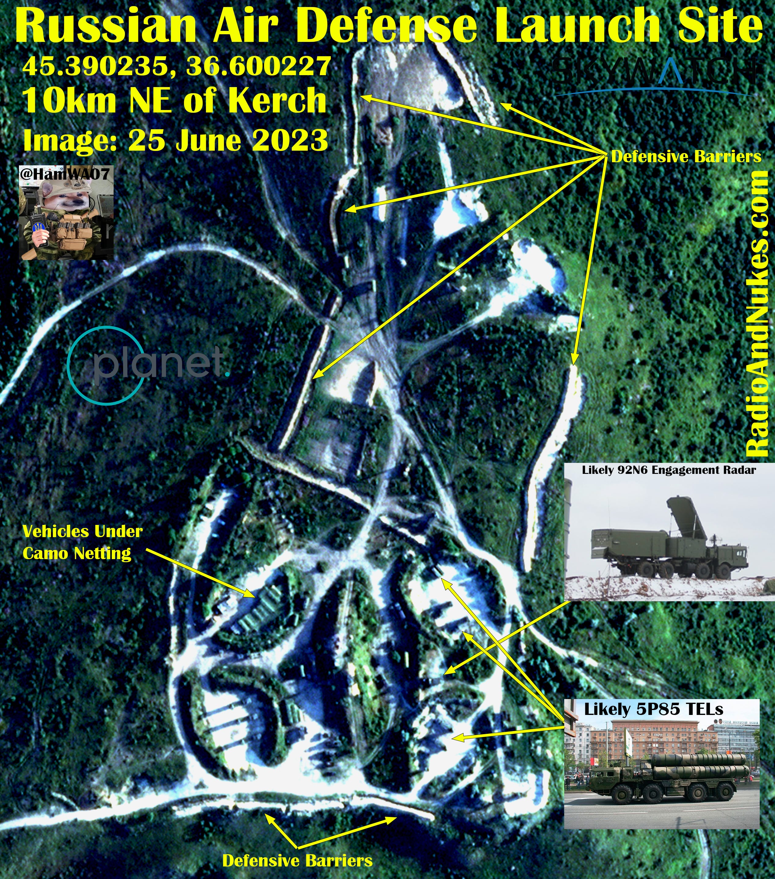
S-400 TELs at the East end of the Kerch Bridge FOUND!
In a massive feat of logistics Russia has moved the S-400 site protecting the east end of The Kerch Bridge, 833 meters northeast. < Satire
I did not have time to do a detailed analysis, so I thought it would be good to get this image out ASAP. I will publish details of the systems at this site soon! Sat Image: ©CNES 2023, Distribution AIRBUSDS Location: 45.2088100,36.6373873 Date / Time: 2023-11-28 08:36:26 UTC Overview Map: Google Maps / RadioAndNukes DB


S-400 TELs at the East end of the Kerch Bridge are missing! Replaced with poor decoys!
Now we have a mystery to solve! The Russian S-400 system that was sitting near the east end of The Kerch Bridge is missing! All that remains are these poor decoys and a few trucks! The question is where did Russia move the equipment?
I have attached an overview map showing the location of the fake TELs and the second S-400 launch site on the west side of the Kerch Bridge.
Sat Image: ©CNES 2023, Distribution AIRBUSDS
Location: 45.2053804, 36.6262030
Date / Time: 2023-11-28 08:36:26 UTC
Overview Map: Google Maps / RadioAndNukes DB


November
Analysis of C-Band 5.305 to 5.505 GHz emissions near Sevastopol Crimea, Ukraine on 2023-11-23 and 24.
All my work is funded by my loyal followers. Please consider supporting my work and more imagery analysis like this! Please consider becoming a free or paid subscriber.
Subscribed
C-Band 5.405GHz +- 100 MHz Emissions likely originating from a radar site near Vesyoloye Krasnodar Krai, Russia.
@scil_int pointed out these pulsed emissions over the eastern Black Sea. If we extrapolate the line to the coast, it passes right over two known radar sites.
Without more data we can’t say with 100% confidence that these domes are the source of the emissions, however it’s likely that these are the source due to alignment of the signal to the sites.
SAR Image: Modified Copernicus Sentinel data 2023/Sentinel Hub
Sat Imagery: Google Earth
Date/Time: 2023-11-06 03:41:41 UTC
Source 1 Blue: 43.4173282, 39.9934850
Source 2 Green: 43.3909823, 40.0008535

Russian S-300 site near Kurbatskii, Krasnodar Krai 2023-10-22.
This site provides overlapping coverage of the Kerch Strait combined with S-400 sites on each end of the Kerch Bridge. The large Radio Engineering (Radar) Site west of Kerch houses multiple early warning radar systems that can cue the launch sites 96L6 acquisition and 92N6 engagement radars. We also know of multiple SHORAD systems, mostly Pantsir providing point defense.
The following equipment is visible at this site.
1 x 92N6 X-Band engagement radar
1 x 96L6 S-Band acquisition radar
5 x TELs likely of the 5P85 series 20 missiles in the launch position
2 x 40V6 mast groups not in use (can be used to elevate the 92N6 and 96L6 radars for better low-level coverage)
Misc support equipment power generators, mains converters, etc.
I have included a line-of-sight coverage plot of the 92N6 at this site.
Note: This is purely a LOS plot it does not account for propagation or radar performance characteristics.
Sat Image: © 2023 CNES AIRBUSDS
Date / Time: 2023-10-22 0821 UTC
Location: 44.9220365, 37.4192148 Near Kurbatskii Курбацкий, Krasnodar Krai Russia Overview Map: Open Street Map / RadioAndNukes DB
Coverage Plot: Cambridge Pixel Software


FAKE S-400 TELs at the East end of the Kerch Bridge!
This is a fun one, we have what appears to be 3x fake TELs painted bright white (85% confidence). I suspect the white paint might be an attempt to throw off the dynamic range of the satellite image making it hard to identify as fake (50% confidence!) This is not the first time we have seen these, but it is the first time I have caught them on a publishable image. The pass cut off the area with where the real TELs were in previous images. It’s possible the real site is operational I have no info to assess that at this time.
I have attached my overview map showing the location of the fake TELs and the second S-400 launch site on the west side of the Kerch Bridge.
Sat Image: © 2023 Planet Labs PBC Powered by Planet
Location: 45.2053804, 36.6262030
Time/Date 2023-11-14 1141UTC.
Image ID: 20231114001
Overview Map: Google Maps / RadioAndNukes DB
Image ID: 20231114002


C-Band 5.405GHz +- 100MHz Emissions in the Azov Sea.
Thanks to @scil_int for pointing out these emissions likely originating from the radar sites near Yeysk Airbase and 23km WSW of Taganrog Airbase.
It’s still unknown which systems are causing this interference or even if it’s the fundamental frequency or a harmonic from 2700MHz S-Band systems. We are still researching this, if anyone has information of which system operates in the 5300-5500MHz range please contact me. Specifically, the 96L6 some sources say C-Band others say S-Band it’s split, Western sources seem to say C-Band while Russian sources state C for “Centimetric”! It gets more fun when Cyrillic C = English S
Sat Image: Modified Copernicus Sentinel data 2023/Sentinel Hub
Location: 46.950, 38.255
Time/Date 2023-11-13 03:32:06 UTC
Overview Map: Google Maps / RadioAndNukes DB

All of the C-Band 5.405 GHz +- 100 MHz since 2023-02-24 across The Black Sea with the known sites overlaid on top.

Mayak Crimea Radar Site 11-12-2023
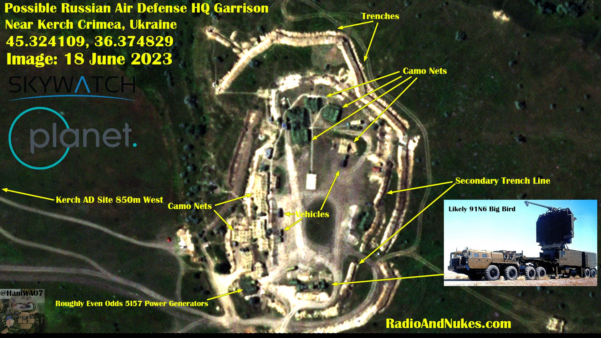
It was time to have a return look at Mayak. The biggest changes are the increased defensive barriers. It appears the large NEBO-M dome built to house the VHF 55Zh6UM is likely vacant as we can see a 55Zh6UM outside just NW of the dome. The dome was damaged in a Ukrainian strike roughly in May 2023. It’s unknow what the stats of the 91N6 Big Bird dome is currently. We can see what looks like two Pantsir AD systems providing point defense for the site 50% confidence.
Image 1: ©CNES 2023, Distribution AIRBUSDS
Date/Time: 2023-11-12 0858 UTC
Location: 45.3458994, 32.5237681
Image ID: 20231112001

Belbek Airbase S-400 Site and the new site 1.2KM NE.
Had a quick look at the Belbek Airbase, Crimea S-400 launch sites. It looks like not much has changed at the main site. The 92N6 and 96L6 radars are covered with a camo net and the TELs are well dug in with defensive berms around them.
What I’m calling Belbek S-400 Site 2 is 1.2 km NE of the 92N6’s antenna. Site 2 has housed both active TELs and decoy TELs in the past. It looks to be empty in this image.
Notable equipment onsite:
1 x 92N6 X-Band engagement radar
1 x 96L6 S-Band acquisition radar
~4 x 5P85 series TELs of the S-300/400 system
Sat Image: © 2023 Planet Labs PBC Powered by Planet
Site 1: 44.7059250,33.5984640
Site 2: 44.7131355,33.6096724
Time/Date 2023-11-10 0738 UTC


Looks like this radar site near Kursk got hit a second time by drone drop. NEBO-U VHF Early Warning Radar 55Zh6U and probably a GAMMA-S1 64L6 (Not super familiar with the GAMMA-S1 were hit.
This site was hit once around 2023-09-30 see next post in thread.
Location: 52.1065343,35.0586229
Video Link https://x.com/WarVehicle/status/1727003214661460231?s=20


October
Please consider a paid subscription here, it would really help fund my satellite imagery analysis. Most imagery will show up first on Twitter @HamWA07 however I’m working on building out SubStack for longer deep dives and of course monthly roundups.
Subscribed
Large Russian S-400 deployment at Rostov-on-Don airport.
I have never seen 10 TELs (40 missiles) at one site. To me the site looks like it was set up in a hurry, this could be indicative of moving between sites to avoid attack or a heightened need for air defenses over Rostov.
The site includes the following equipment.
10 x TELs
1 x 92N6 Grave Stone X-Band engagement radar
1 x 96L6 Cheese Board S-Band acquisition radar
Misc support equipment
The regimental 91N6 Big Bird S-Band battle management radar is located SW of Rostov at 47.087559, 39.609864 see overview map.
I have included a line-of-sight coverage plot of the radars at this site. Note: This is purely a LOS plot, it does not consider propagation or radar performance characteristics. Thanks to all the hard work by @Dmojavensis for geolocating launches from this site! Everyone that helps with these IDs thank you!
Sat Image: ©CNES 2023, Distribution AIRBUSDS
Date/Time: 2023-10-29 0816 UTC
Location: 47.2625945, 39.8197490
LOS Plot: Cambridge Pixel Software
Overview Map: Open Street Map / RadioAndNukes


New Construction Near Belbek Air Base Crimea, Ukraine Russia continues building these sites all over Crimea which appear to be setup for air defense. Until we see systems at this site, I’m going to keep it classified as unidentified new construction in my database.
This site has 5 large revetments, ~9 fox holes and 2 small trenches.
H/T @scil_int for locating this site,, great work as always!
Sat Image: © 2023 Planet Labs PBC Powered by Planet
Location: 44.7131385, 33.6101686
Time/Date 2023-10-26 0823 UTC
Overview Map: Open Street Map / http://RadioAndNukes.com


Russian S-400 Shell Game in Crimea!
This is interesting, after the strikes and raids on the west coast of Crimea Russia is starting to play the shell game with air defense assets. Systems are moving around more, decoys are rumored, and we are noticing new sites being stood up quickly. The middle site was active in September but as of 2023-10-23 it’s empty. Due to clouds recent imagery of the top site has not been available.
We are keeping a close eye on these sites and will report on further movements depending on project funding.
I have attached an overview of Crimea; this map isn’t comprehensive, it’s just the sites I have focused on.
Sat Image: © 2023 Planet Labs PBC Powered by Planet
Location: 45.456779, 32.734134
Time/Date 2023-10-23 1211 UTC
Overview Map: Open Street Map /
http://RadioAndNukes.com


Belbek Air Base S-400 Site. First off this image has very poor lightning conditions hiding things in the extreme contrast between the light soil and the dark green of the vehicles. I’m confident that this is a S-400 launch site and of the 92N6 radar, everything else in the image was very tough to ID. From looking at this site previously, I suspect a typical arrangement of the 92N6 radar and a row of TELs. Likely a Pantsir for point defense.
I have attached an overview of Crimea; this map isn’t comprehensive, it’s just the sites I have focused on.
Sat Image: © 2023 Planet Labs PBC Powered by Planet
Location: 44.7058080, 33.5984971
Time/Date 2023-10-26 1206 UTC
Overview Map: Open Street Map / RadioAndNukes.com


Belbek Air Base Radar Site 2023-10-26.
Having a closer look at the radar site located at Belbek Air Base Crimea, Ukraine. It looks quite active with the following systems. 2 x 5Zh6U NEBO-U VHF Early warning radars.
1x 96L6 Acquisition radar of the S-300/400 system or stand alone
1x Pantsir-S2 Air short range defense system
1x RSP-27 Approach radar used to help aircraft land not AD
I have included a line-of-sight coverage plot of the radars at this site. Note: This is purely a LOS plot it does not take into account propagation or radar performance characteristics.
Sat Image: © 2023 Planet Labs PBC Powered by Planet
Location: 44.677372, 33.553443
Time/Date 2023-10-26 1206 UTC
LOS Plot: Cambridge Pixel Software


C-Band 5.405GHz +- 100MHz Emissions near Primorsko-Akhtarsk Air Base 2023-10-25. Thanks to @scil_int for pointing out these emissions likely originating from the radar site just west of Primorsko-Akhtarsk Air Base.
Sat Image: Modified Copernicus Sentinel data 2023/Sentinel Hub
Location: 46.066375, 38.192028
Time/Date 2023-10-25 03:40:26 UTC

Some air activity around of Yeysk, Taganrog, and Primorsko-Akhtarsk Air Bases along the Azov coast.

Small boats at Sevastopol’s Khersones Air Base / Kozacha Bay 23 October 2023. I found this interesting, seven small boats roughly 13.7 x 4.7m +- 1m sitting on a concrete pad near the dock on Kozacha Bay.
Sat Image: © 2023 Planet Labs PBC Powered by Planet
Location: 44.583014, 33.399832
Time/Date 2023-10-23 0813 UTC.

Russian K-300P Bastion-P TEL, Sevastopol Crimea, Ukraine 23 October 2023 Here we can see what is very likely a K-300P Baston-P TEL (Transporter Erector Launcher) located within Khersones Air Base in Sevastopol. This is near the former Denepr space surveillance / missile warning radar. Thanks to geolocated launch footage we found this TEL see QT. This system launches the P-800 Oniks supersonic cruise missile that’s been used against Ukraine multiple times.
Sat Image: © 2023 Planet Labs PBC Powered by Planet
Location: 44.5825981,33.3933826
Time/Date 2023-10-23 0813 UTC
Google Maps Link: https://maps.app.goo.gl/kHf4vgzkUCvbhXM48…

Russian communications site with new defensive positions 4km NW of Olenivka Оленевка, Crimea Ukraine. This site is not new, it goes way back, however I find I very interesting that a new defensive arc was built around one tower but not the other. This ring of defenses could mean this tower is important for C4ISR. We will keep watching this site.
I have included a line of sight plot (Image 2) for a 60m tower to a 5m object. This would be the approximant visual range of EO camera equipment on the top this tower. Image 3 is a plot of the rough radio range to aircraft at different altitudes AGL from 100m to 10000m from top of this tower.
Image 1: Sat Image: © 2023 Planet Labs PBC Powered by Planet Location: 4km NW of Olenivka Оленевка, Crimea Ukraine 45.404533, 32.489785
Time/Date 2023-10-22 0729 UTC
Image 2/3: Cambridge Pixel Software


Subscribed
Russian radar site near Prymors'kyi, Crimea with a drive-through radar dome likely built to house a 91N6 / 64N6 NATO codename Big Bird S-Band acquisition / battle management radar. It’s impossible to tell if the radar is present at the site from this image alone, however the site appears to be active and has had traffic come and go over the last two months looking at Sentinel-2. I will keep an eye on this site and others going forward to see if we can narrow down the location of the Big Bird radar in this part of Crimea.
I have included a line-of-sight coverage plot of the radars at this site. Note: This is purely a LOS plot it does not consider propagation or radar performance characteristics.
Sat Image: © 2023 Planet Labs PBC Powered by Planet Location: Prymors'kyi Приморський Crimea, Ukraine 45.146389, 35.502437
Time/Date 2023-08-15 1336 UTC
LOS Plot: Cambridge Pixel Software


Big Bird hiding in the trees near Voronezh, Russia.
Here we have a 91N6 NATO codename Big Bird radar just SW of Voronezh. The 91N6 is the latest version of target acquisition radar for the S-400 complex. It is an upgrade from the 64N6-2 that was part of the S-300PMU2 system. Each command battery is equipped with one Big Bird, it also appears to be backwards compatible with S-300PMU systems. The presents of a 91N6 / 64N6 radar typically means a regimental level command center is nearby.
I have included a line-of-sight coverage plot of the radars at this site. Note: This is purely a LOS plot it does not consider propagation or radar performance characteristics.
Sat Image: ©CNES 2023, Distribution AIRBUSDS Location: 51.597610, 39.084901 Time / Date: 2023-09-23 0841UTC
LOS Plot: Cambridge Pixel Software


Belgorod Long Range Radar Site
Very interesting site, which houses modernish radars mixed with old Soviet equipment including one Frankenstein system we haven’t been able to identify. The site sits 12km NE of Belgorod City along the 14K-1 highway.
Some of the systems at the site include: 55Zh6 NEBO-U VHF early warning radar 36D6 3D S-Band radar can be of the S-300 complex 59N6? Protivnik-G L-Band 3D radar part of the NEBO-M complex 1RL130 or 1RL141? Nodding height finder of older Soviet Design Note: ? Denotes low confidence less than 50%
This brings us to the unidentified (UNID) Frankenstein radar that looks like a Gamma-DE phased array panel connected to an older Soviet radar pedestal? That panel could also be an IFF antenna. If anyone knows what this thing is, please let me know.
Nothing much more to say about this site other than it dates to Soviet times and appears to get quite a bit of traffic. The 5Zh6 NEBO-U, 36D6 and 59N6 are modern capable systems and appear to be operable as of 2023-08-20, If I can source more recent imagery, I will revisit this site.
I have included a line-of-sight coverage plot of the radars at this site. Note: This is purely a LOS plot it does not take into account propagation or radar performance characteristics.
Sat image: © 2023 Planet Labs PBC Powered By Planet Location: 50.669645, 36.725481 Time / Date: 2023-08-20 0756 UTC
LOS Plot: Cambridge Pixel Software
Thanks for the help @strannik_1981


Belbek Crimea, Ukraine Air base S-400 launch site.
The previous image from 2023-09-29 (Fig 2) shows both a 92N6 and a 96L6 radar on site with 5 TELs in launch configuration. The new image from 2023-10-04 (Fig 1) shows no visible radar on site with the previous TELs all in the stowed position. The odd part 330 meters NW of the original location we can see 2 TELs in the firing position with no radar in site. The lack of radar near the TELs suggests 1. Either these are more modern 5P90 TELs with microwave backhaul, 2. I haven’t found the radars yet, or 3. The radars are missing making the site inoperable.
Fig 1: © Airbus DS 2023
Date/Time: 2023-10-04 0906 UTC
Location: 44.706019, 33.598752
Fig 2: ©CNES 2023, Distribution AIRBUSDS
Date/Time: 2023-09-29 0848 UTC
Location: 44.705877, 33.598860


Sevastopol S-400 Launch Site
2023-10-04 Nothing much out of the ordinary to speak of with this site, it’s a very standard deployment of S-300/400. I have included a line-of-sight plot of the 92N6 radar. Note: The LOS plot represents line-of-sight only, it does not depict the range of the missiles or take into account detection range of the 92N6 radar.
4X TELs from the 5P85 family
2X 40V6 40-meter masts
1X 92N6 X-Band engagement radar
Sat image 1: © Airbus DS 2023
Date/Time 2023-10-04 0907 UTC
Location: 44.544405, 33.432415
Radar Line-of-sight plot: Cambridge Pixel Software


NEBO-U radar operating near Sevastopol Crimea, Ukraine Image 1. The 55Zh6U NEBO-U is a long-range VHF (Probably 140-180MHz) radar system. VHF radars are designed to detect low RCS targets by exploiting resonance. VHF radars can see LO threats; however they have a huge drawback in the fact they can't produce a target quality track. The data is from a VHF radar is not accurate enough to guide an interceptor missile to a threat. In practice these early warning radars cue higher frequency radars to look in the general direction of the threat and wait until they can produce a target quality track, which is not always possible.
Image 2: I have attached a screenshot from a NEBO-U radar display showing the poor special resolution of the objects detected.
Image 3: I have also provided a Cambridge Pixel line-of-sight plot of this radar. Note: Cambridge Pixel is purely a line-of-sight plot it does not take into account propagation or radar characteristics.
Site History: This NEBO-U has been at this site since 2015 with no apparent movement of the support vehicles.
Image 1: Sat Imagery: ©CNES 2023, Distribution AIRBUSDS
Date / Time: 2023-09-24 1218 UTC
Location: 44.530014, 33.459273 NEBO-U
Example Image Source: https://radartutorial.eu/19.kartei/02.surv/karte039.en.html…
Image 2: Source: https://shephardmedia.com/news/digital-battlespace/cmds-air-defence-division-receives-nebo-u-radar-st/…
Image 3: Source: Cambridge Pixel Software


New Russian S-400 launch site located at 44.705877, 33.598860 just east of Belbek Air Base is now active, with 5x 5P85 TELs in launch configuration! Both a 92N6 engagement radar and a 96L6 acquisition radar are present on elevated berms. I have included a plot showing the line-of-sight coverage from the 92N6 berm of the Belbek site. It appears likely the TELs and radars at this site were relocated from the S-400 launch site near Yevpatoriya that was attacked earlier in September. I have included a second plot of the former Yevpatoriya launch site, it appears the new Belbek site can provide nearly the same coverage of The Black Sea west of Crimea.
Note: This site like many used by Russia in Crimea appears to date back to Soviet times.
Image 1:
Sat Imagery: ©CNES 2023, Distribution AIRBUSDS
Date / Time: 2023-09-29 0848 UTC
Location: 44.705877, 33.598860
Image 2: Belbek 44.705877, 33.598860 coverage plot Cambridge Pixel
Image 3: Yevpatoriya 45.176572, 33.243920 coverage plot
Cambridge Pixel Cambridge Pixel plot color table corresponds to target altitude above ground level in meters. Key is in the bottom right of the plots.


Russian Gvardeyskoye Air Base Air Defense Site. This site was prepared in April 2023, however it appears as of 2023-09-20 the site wasn't fully setup. Looking at the more recent ground pics from
the 96L6 is now inside a protective berm. I have also attached a Cambridge Pixel line-of-sight plot showing the potential coverage of the 92N6 radar.
Image 1: Sat image: ©CNES 2023, Distribution AIRBUSDS
Date/Time: 2023-09-20 0906 UTC
Location: 45.085770, 33.937294
Ground Image: @AteshOrg
Image 2: Source: Cambridge Pixel Software


Here is an image of the 336th Radio Technical Regiment m/u 03013-2 that was hit by a Ukrainian drone drop. This image appears to be before the strike took place. Not much other than a NEBO-U 55Zh6U VHF long range radar at this location near Dmitriyev
Imagery: © 2023 Planet Labs PBC / Powered By Planet
Location: 52.106769, 35.059487 Dmitriyev Дмитриев-Льговский Kursk Oblast, Russia Date / Time: 2023-09-24 1216 UTC

The Russian NEBO-U VHF long range radar that was attacked by Ukranian drone drop was located at 52.107225, 35.058916 near the town of Dmitriyev Дмитриев-Льговский Kursk Oblast, Russia
336th Radio-Technical Regiment military unit 03013-2 according to the Russian Military Index

September
Strong C-Band 5.405MHz +- 100MHz emissions from Volgograd Oblast, Russia 2023-09-09 03:23:06 to 03:23:31 UTC.
Most of the radar emission we have seen on Sentinel-1 appear to originate from BUK air defense systems. The 9S18 Snow Drift, 9S36 radar or the radar built in to the TELAR. The source of these emissions remains unknown.
We have also noted large amounts of interference from the Voronezh RCS test range and The Rostov-on-Don Institute of Radio Research! But it tends to be less pulse like without obvious pulse compression unlike these emissions.
Source: European Space Agency / Modified Copernicus Sentinel data 2023
Site 1 top image: Near Frolovo Фролово, Volgograd Oblast, Russia 49.718611, 43.768611
Site 2 bottom image: Near Ryabovskii Рябовский, Volgograd Oblast, Russia 49.946927, 41.569437
Thanks for the heads up from @Rb3qzWR5AK5nooA

Raw I/Q that was used to make the above image. You can see the radar pulses (red outline) and something else (blue outline) possibly data or a very high PRF radar mode.


Here is a satellite image of the vessels in the dry dock that was struck in Sevastopol. It appears to be a Ropucha-class Project 775 landing ship and a Kilo class submarine. Image date / time: 2023-09-12 0735 UTC
Image source: © 2023 Planet Labs PBC Powered by planet. 44.610545, 33.537475 Thanks for the help:
@HelloMrBond @exit266 @Misfit4Ukr68491 @Mattl8241

Enhanced close up of the #Sevastopol drydock using only Planet SkySat Band-2 Green 515-595nm.
Image source: © 2023 Planet Labs PBC / Powered by Planet.
Image time / date: 2023-09-12 0735 UTC

We had a go at processing CPHD files from @capellaspace to see if the radar emissions were visible in a FFT of the Complex Phase History Data, sure enough! It looks like X-Band marine radar pulses and some non pulsed emitters of some kind, I would guess microwave datalinks. We need to put some more work into this but it's really cool to see these radar waveforms. Next step is to verify this 110% without a doubt, but it's looking possible to recover useful emitter information from CPHD SAR data.
Image source: Capella Space opendata X-band (9.4 – 9.9 GHz)


S-3/400 site BDA near Yevpatoriya Crimea, Ukraine 2023-09-14. Russian Air Defense forces have pulled back most of this S-3/400 launch site. The images are roughly one hour apart with the Planet image at 0746 UTC and the AirBus NEO image 0852 UTC. Note several vehicles have been moved from the site in one hour!!! We will need to revisit this location to verify if this is a temporary measure.
Image 1: © 2023 Planet Labs PBC 9/2023 Powered By Planet.
Image 2: © Airbus DS 2023 Pléiades Neo
Location: 45.1762550, 33.2419743


This area is 1165m NW of the previous site. It appears to also be a S-3/400 site. That maybe a 92N6 radar in the central berm 50/50. It appears the vehicles in the square are transporting missile tubes.
© Airbus DS 2023 Pléiades Neo 2023-09-14 0852 UTC 45.1810881, 33.2293284

Overview of Russian Air Defense sites around Yevpatoriya Crimea, Ukraine.
Imagery: Sentinel Hub

I suspect this is nothing, but it's worth posting so others don't go down the rabbit hole. FIRMS showed several fire spots in the military training area just north of Tiraspol, Transnistria. The Sentinel-2 pass earlier today revealed large burn scars in the training area extending into the old Soviet airbase. It's hard to say if this was a controlled burn or a fire caused by training activates.
Image 1: Modified Copernicus Sentinel data 2023/Sentinel Hub / Russian Military Index 1.45
Image 2: Google Earth Pro / NASA FIRMS


It appears that the Protected Command Post of the Black Sea Fleet may have been hit. Nothing can be seen on this 3 meter Planet Scope imagery. Looking for better imagery now! If this was a bunker bust it's likely we will need high res imagery to see the entry point. I will post updates as new info comes in.
Imagery: © 2023 Planet Labs PBC / Powered By Planet.

After some enhancement it appears likely this 4 meter circle is the impact point of the missile that struck the Protected Command Post of the Black Sea Fleet on 9-20-2023. The entire southern wing of this building complex was destroyed in the strike. We do not yet know the status of the underground complex.
Image 2, shows the building pre strike.
Lat/Lon: 44.7145006, 33.7047871
Time/Date: 2023-09-21 0521 UTC
Image 1: © 2023 Planet Labs PBC / Powered By Planet.
Image 2: Google Earth Pro


We found something! This site is on the northwest Crimean coast near Kotovs'ke, and may have been emitting in the C-Band 5.405GHz +- 100MHz on and off since May 2023. @scil_int located this using Sentinel-2 we then acquired an older Airbus Neo image of the site. I am not 100% sure this is the emitter source, it could be high power radar emissions from the well-known Mayak radar site. The systems likely to show up on Sentinel-1 in the C-Band are BUK Snow Drift radar 9S18 and the 96L6 radar of the S-400 family.
Image 1: © Bellingcat Radar Interference Tracker by @oballinger 9-24-22 to 9-24-23 / Sentinel-1
Image 2: © Airbus DS 2023 Pléiades Neo 5-24-2023 45.7303833, 33.1556097
Image 3: © Airbus DS 2023 Pléiades Neo 5-24-2023 45.7303833, 33.1556097


Dzhankoy Crimea S-400 Launch Site 2023-09-24 0836UTC. The S-400 site is still quite active with both a 92N6 engagement radar and a 96L6 acquisition radar present and on site. 5 TELs can be seen setup and ready to fire 48N6 missiles. We are still assessing the reported strike near this site. A large burn scar exists just to the north of the AD area. I have decided to wait for more imagery regarding the attack as we can not identify what if anything was hit.
Imagery: 2023 CNES Distribution Airbus DS

New bridge under construction, likely a new railroad as mentioned below. Just south of Staromar'ivka Старомар'ївка, Donetsk Oblast
Location: 47.4236, 37.8615
Imagery: © 2023 Planet Labs PBC
Time: 2023-09-25 0734 UTC

Composite image of 5.405GHz +- 100MHz SATCOM emissions near the Mayak, Crimea Ukraine. From 3-27 to 9-25-2023. 45.347567, 32.504132 After extensive comparisons these emissions are highly likely to be SATCOM (satellite communications) emissions vs radar emissions. We have noted these from three sites. Mayak, near Luhansk and Moscow over the last 6 months. They all appear to be associated with air defense units.

I have no idea what happened at Dzhankoy Air Base Crimea, Ukraine between 2023-09-18 and 2023-09-24! Something new was built in the area of the grassfire, which is all we can conclude from this imagery. 1: Burn scar / grass fire 2: S-400 site 3: Vehicles leaving the base
Imagery: ©CNES 2023, Distribution Airbus DS Location: 45.687790, 34.406873
Image 1 (before): 2023-09-18 0832 UTC
Image 2 (after): 2023-09-24 0836 UTC
We had a look at this possible Russian air defense site 1km NE of Belbek Air Base Crimea. This site appears to be an old pre-prepared AD site with some recent activity. It is possible the S-400 TELs evacuated from Yevpatoriya have been / will be moved to this site, we don’t have enough information to confirm yet. We will be keeping an eye on this site going forward.
Imagery: ©CNES 2023, Distribution AIRBUSDS
Date / Time: 2023-09-25 0830 UTC 44.70580, 33.59878

Quite a few burn scars around the Kerch peninsula as of 2023-09-30. It does not appear the Kerch S-400 site or the Kerch Radar Site were damaged. However it's difficult to say for certain using low resolution imagery.
Imagery: Modified Copernicus Sentinel data 2023/Sentinel Hub
Date/Time: 2023-09-30 0957 UTC
Location: 45.36227, 36.35965 Kerch Crimea, Ukraine

August
C-Band 5.405GHz radar emissions from the central Black Sea 20230803 23:59 to 20230804 00 UTC Several ships can be seen in the area mostly moving southwest towards the Bosporus.


Starokostiantyniv Air Base Khmelnytskyi Oblast, Ukraine 49.7475, 27.271944 2023-080-06 0856UTC Post attack, very little damage to base infrastructure can be seen on this medium res image.

Two large ships off Crimea 2023-08-07 03:49 UTC. The ship ~20km south of the Crimean coast has a close match to Prima however it's not perfect. The ship hugging the coast is unidentified. I saw several small pleasure / fishing vessels but nothing of that size on AIS. It's possible it's a smaller ship that has a high RCS at 5GHz Imagery: Modified Copernicus Sentinel data 2023/Sentinel Hub

Frontline Robotyne to Verbove Sentinel-2 NIR 2023-08-06. A large area of burn scars can be seen denoting heavy fighting. The edge of recent agricultural activity can clearly be seen. Note: The burn scars do not indicate forward line of control.

Quite a bit of talk about Kherson Oblast today. Here is Sentinel-2 imagery from 2023-08-07 08:57:26 UTC with a 8-8 FIRMS overlay. We will need some time for things to progress to make any calls about what's going on in this area. Analysis ongoing.

Updated maps of the Robotyne and Urozhaine areas with terrain, rail, major roads and Russian Defenses. Sentinel-2 base imagery is from 8-9 today was total cloud cover. Russian field fortifications courtesy of @bradyafr


Imagery of Mezhevaya railyard. It appears the damage is minimal considering the size of the fireball in the video. Great analysis below by @Schizointel
Imagery: 2023 Planet Labs PBC / SkyWatch
Map: OpenStreetMap


C-Band / NATO G-Band 5.405GHz +- 100MHz radio emissions from the area near Oster / Roslaval Smolensk Oblast, Russia 2023-08-17 16:51:22 UTC

The C-Band / NATO G-Band emissions from from the area near Oster / Roslaval Smolensk Oblast, Russia, yesterday had a very hot pixel in the white bar on the right side of the SAR image >3σ. I ordered a 50cm Planet Skysat image from earlier today to see if that spot might correspond to the source. The results are inconclusive! We see an area of new vehicle tracks and a clearing where a radar could have been parked. The time delta between images could be too much and the vehicle moved, or this is not the source area. The great radar hunt continues. ESA Sentinel-1A C-Band / NATO G-Band 5.405GHz +- 100MHz radio emissions 2023-08-17 16:51:22 UTC Planet Skysat 50cm 2023-08-18 1218 UTC Thanks: @Misfit4Ukr68491 and @NZ_Trav for having a look. Hot Pixel: 53.98829542435541, 32.844433668785264 https://goo.gl/maps/QF3jqQAfDNu26V6P6… Optical image: © 2023 Planet Labs PBC / Powered by Planet SAR data: Modified Copernicus Sentinel Data

Just as @davidhelms570 forecast the atmospheric conditions around the Tokmak axis are perfect for ISR. Using SWIR several active fires are visible in the gray circles. Source: Modified Copernicus Sentinel data 2023/Sentinel Hub 2023-08-19 0847 UTC 47.3, 34.8

8-19 Ammunition depot near Lysohirka Лисогірка, Khmelnytskyi Oblast, Ukraine was hit. We have some more imagery to go with this awesome thread by @Schizointel It appears that two bunkers were destroyed leaving a crater nearly 100m wide. Smoke is obscuring the eastern bunker (top right). A large hot spot can be seen using Planet Scope Band 8 NIR 856nm imagery. Please see @Schizointel thread for analysis of the site. Source: © 2023 Planet Labs PBC Powered by Planet 2023-08-19 0856 UTC Coords: 49.34970212124488, 27.441834297835598 Thanks everyone who helped with this analysis.
@Misfit4Ukr68491 @Mattl8241 @Schizointel @HelloMrBond
Thank you
for pointing this out.


Destroyed (Not damaged) Tu-22 Soltsy-2 Airbase 58.132985, 30.328679 2023-08-21 1229UTC Imagery: © 2023 Planet Labs PBC Powered by Planet Thanks for the help! I thought that was vegetation at first! @Misfit4Ukr6849 @Mattl8241

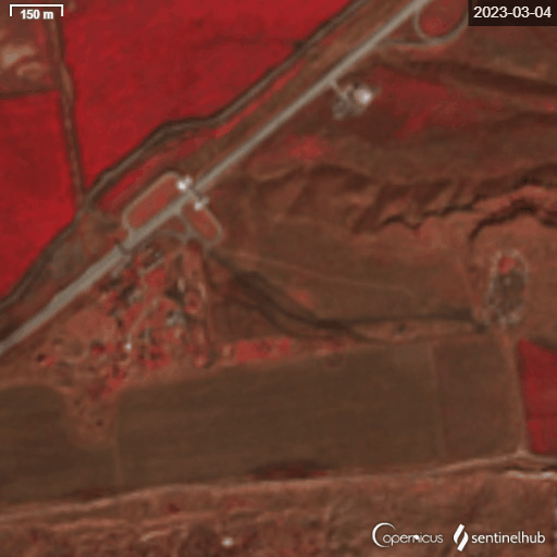
Here are satellite images of this site before it was hit by Ukraine. It’s located a few km NE of Olenivka Оленевка Crimea. I would guess the large explosion is a one of the TELs

Here is the information we have so far. RA02795 was in range of multiple radar sites at the time of the incident, I have plotted the closest three. The crash site of RA02795 is 68km ~37NMI from the 42nd Guards Anti-Aircraft Missile Regiment HQ S-300PM site. The site is equipped with a 92N6 Grave Stone engagement radar on a 40V6M 30m or a 40V6MD 40m mast and several S-300 TELs. The 40V6 mast is used to elevate the X-Band engagement radar above the tree line to provide a clear line of sight to the target, this height also helps with low level target engagement. At 28,000ft or ~8540m RA02795 was clearly in range of the 92N6 S-300PM engagement radar at the 42nd Guards Anti-Aircraft Missile Regiment HQ 58.069994, 32.959746. S-300P/400 systems use the 92N6 radar to guide the interceptor missile to the target. Conclusions, RA02795 was in range of at least one S-300 site at the time of the incident and it was clearly in range of the 92N6 radar and 48N6 missiles! Nothing more can be confirmed at this time.
Imagery: © 2023 Planet Labs PBC Powered By Planet / SkyWatch / ©CNES 2023, Distribution AIRBUSDS
Map: Open Street Map
Aircraft track: Flightradar24
Thanks for the help from
@HelloMrBond @thenewarea51 @PowerPigeon2 @MT_Anderson @Mattl8241 @Misfit4Ukr68491 @Kd7qkPaul
Sorry if I missed anyone

Band 8 NIR Planet Scope image of the destroyed S-300/400 TEL at Olenivka Crimea, Ukraine 45.419622, 32.541217 2023-08-24 I have imagery of the Mayak radar site to the SW of this. It doesn't show any obvious signs of damage.
Imagery: © 2023 Planet Labs PBC Powered by Planet

July


June


May
SNPP Night Band of the #NovaScotia fire 5-29 vs 5-27


Just looking at the #NovaScotia fire in Sentinel EO Browser. Sentinel-5P UV Aerosol Index, Carbon Monoxide, Nitrogen Dioxide, Sentinel-3 Enhanced True Color. I need to remember other satellites and products exist that contain a lot of useful data! #OSINT


Canadian fire SWIR image from ESA Sentinel-2 15:20UTC, Current radar imagery showing a frontal boundary about to change wind direction, Surface analysis showing rough position of the cold front. Winds ahead front WSW 5 gust 15kts behind NW 15 gust 25kts #NovaScotia


Another R-330Zh Zhitel EW system destroyed. Infographic I made the other day

Zaporizhzhia Nuclear Power Station. You can see the cooling sprayers turn on and off in ESA Sentinel-2 imagery 5-21 vs 3-27. It would be interesting to make chart over time. Just an observation.

Turbulent water shows up on Sentinel-1 VV polarization quite well.

After the shootdowns Belgorod Oblast has come alive with C-Band 5.405GHz emissions. These look pulsed and are likely air defence radar systems. More analysis to come. Thread will populate slowly as I process the data today.


It was hard to map this it's on such a large scale!


More C-Band emissions from Mayak Crimea, Ukraine 45.347580, 32.504119. Bottom edge of the square appears to be the source.


Some dirt work at Taganrog Airbase left 5-3 right 5-15


Aircraft ~17km off of occupied Kyrylivka, Ukraine in The Sea of Azov 46.24210, 35.48038 moving NE at ~215m/s or 418kts Imagery ESA Sentinel-2 2023-05-13


Bands 4,3,2 are used for this RGB stack with 1.005s between the red band 4 and blue band 2. Ballpark the aircraft moved 215m in 1 sec = 215m/s or 418kts towards red. Using blue and green I get 228m/s well within the margin of error.


Nova Kakhovka Dam / Kakhovka Hydroelectric Power Plant still flowing at a high rate. 2023-05-08 03:56:57 - 03:57:22

Weak C-Band 5.4GHz emitter near Mikhailovski, Belgorod Oblast 51.3800, 37.4268 2023-05-06 15:21:43 to 15:22:01 UTC. I included a digital elevation model. It wouldn't make sense to place a radar in a valley, I suspect the location to be on the hills around the valley.


Unknown weak C-Band radar emissions 47.10083, 33.88279 2023-05-04 15:36:55 - 15:37:20 UTC Russian side of the Dinpro

Ships near Rostov-on-don, Russia Sea of Azov 2023-05-01 15:12:20 - 15:12:45 UTC. Synthetic Aperture Radar SAR imagery from ESA Sentinel-1

Rostov-on-Don Research Institute of Radio Communications 47.354415, 39.784885 emitting a non pulsed signal in the 5.3-5.5GHz range 2023-04-19 15:12:19 - 15:12:44 UTC


Russian C-band 5.3-5.5GHz radar system active near Bilosarais'ka Kosa Білосарайська Коса 2023-04-17 15:28:35 UTC to 15:29:07 UTC Emitter location estimate 46.931288, 37.367445

