


🛰️ From Cold War to Crimea Today
From KH-9 HEXAGON spy satellites to today’s sensors — 40 years of transformation over Crimea, revealed from orbit

In 1984, an American reconnaissance satellite known as KH-9 HEXAGON captured high-resolution film photographs of strategic locations across the Soviet Union, including the port city of Sevastopol in Crimea.
Inside the KH-9: Satellite Design
Often referred to as "Big Bird," the KH-9 HEXAGON was a Cold War-era photo-reconnaissance satellite with panoramic cameras mounted in a long bus-sized frame. It flew in low-Earth orbit and was tasked with imaging vast swaths of territory in remarkable detail.


Capturing the Cold War: The Film Medium
KH-9 used large rolls of high-resolution black-and-white film capable of capturing objects at 2–4 foot resolution. This analog film had to endure the harsh environment of space and be physically retrieved for analysis.

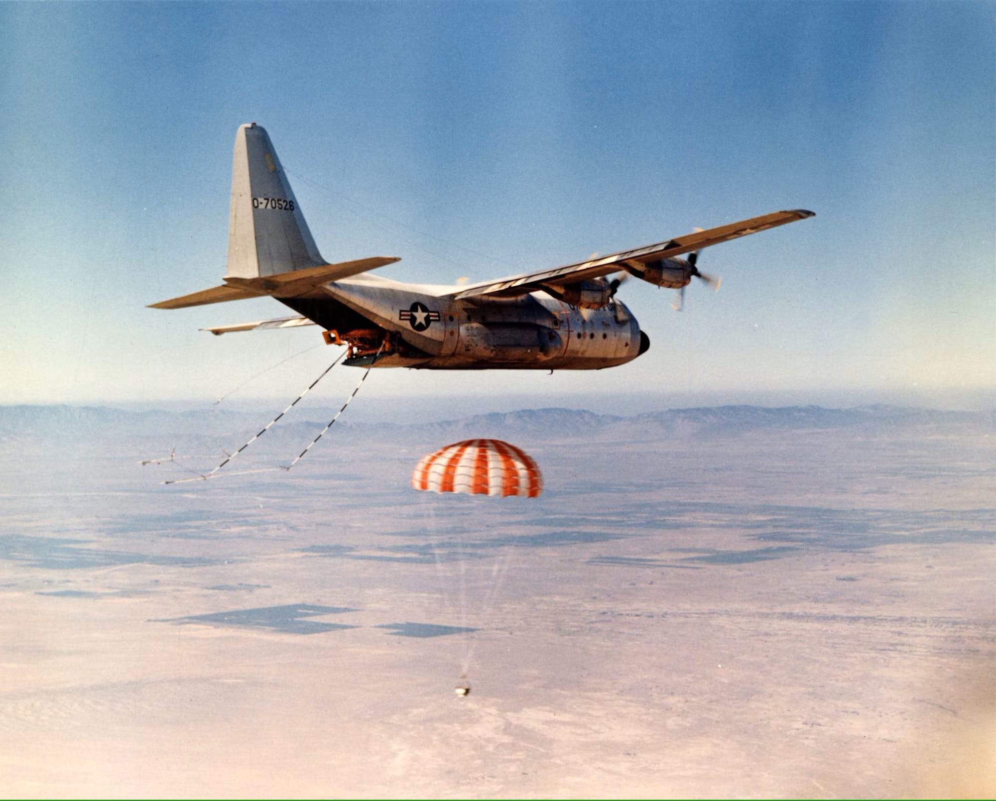
Return to Earth: Film Recovery Missions
These were top-secret missions — the film was physically returned to Earth in canisters ejected from orbit. Special recovery aircraft caught the parachuting canisters mid-air before they landed in the ocean.
Forty years later, that same imagery has been declassified, digitized, and made available by the USGS. Leveraging this data, I've built a visual time-lapse that transitions seamlessly from 1984 to the present day, revealing how military, industrial, and civilian landscapes have evolved.
Watch the Clip
How It Was Done
Archival Imagery
KH-9 HEXAGON imagery (Mission 1219, Frame D3C1219-200712F008) acquired on September 10, 1984.
Coordinates: 44.864 N, 33.259 E — central Sevastopol.
Resolution: 2 to 4 feet, comparable to modern commercial satellite standards.
Modern Satellite Views
I used Bing Maps high-resolution satellite imagery (2020s) from and synced it with the 1984 frames.
Geometric Alignment
Fiducial marks in the KH-9 film were auto-detected to correct geometric distortion.
QGIS and OpenCV were used to align both eras, generate fade transitions, and export frame-accurate clips.
Post-Processing Pipeline
Processing and automation: Python, NumPy, SciPy
GIS integration and export: QGIS
Frame manipulation and transitions: OpenCV, MoviePy
Video encoding and editing: FFMPEG, OpenShot
Environment: Ubuntu Linux
KH-9 HEXAGON Technical Notes
Altitude: 80–370 nautical miles
Mission duration: 124 days average
Panoramic cameras: Perkin-Elmer, 60-inch focal length f/3.0, aperture 20 inches
Mapping camera: Itek, 12-inch focal length f/6.0, 9.5-inch film, with two Itek 10-inch focal length f/2.0, 70mm film cameras for star-tracking position reference
Film: Length 320,000 feet (about 60 miles), width 6.6 inches
Film return vehicles: Four (five if mapping camera used)
Film load: 52,000-77,500 feet of film maximum per vehicle
Film weight: 500 lbs. maximum per vehicle
Vehicle weight: 956 lbs.
Audio Lecture Links
Dr. Robert McDonald & Dr. James Outzen: "Space Reconnaissance" (01:02:22)
Phil Pressel: "The Hexagon KH-9 Reconnaissance Satellite" (00:50:16)
Very professional imagery collection and historical correlation. One can see the money the Soviet Union poured into the Ukraine SSR building radars, naval bases, rail links, airfields and industrial facilities over this time period. Too bad they didn't do nearly as much on civilian infrastructure.
This is amazing work!